Sewer Plan
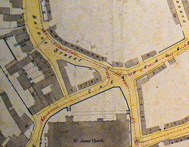
North of St James' Church
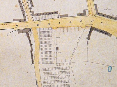
Cattle Market
One of the most scruffy items in the museum, but which is greatly appreciated by many of us, is the “Sewer Plan”. This is a book of detailed maps of the town of Louth, drawn in the 1870s.
The maps were produced by the Louth Borough Surveyor, Henry Louis Delabene Marsden, a land surveyor who lived in George Street. We know from the autobiography of woodcarver Thomas Wilkinson Wallis that in February 1885 Marsden resigned due to 'an unhappy time with some of the committees', and Wallis succeeded him as Borough Surveyor.
It was Wallis, with his concern for improved sanitation (there had been serious epidemics of typhoid and smallpox in the town), who added the sewers to Marsden’s maps.
For many decades these maps were used by the Council, but gradually they became superseded by more modern maps. In 2002, John Barker was instrumental in acquiring the Sewer Plan for Louth Museum.
The Sewer Plan records the town as it was in mid-Victorian times and shows us the exact location of buildings that have long since been demolished, the names of former inns and public buildings, and the house numbers - such a valuable resource when trying to work out exactly where families lived.
The first of the images shown here is the area to the north of St James’ Church. On the west side of Bridge Street, where there are now grassy areas, were cottages and a pub called the Queen’s Head.
The second image shows the cattle market, and the layout of pens for cattle and sheep.
Thanks to grant funding from the Lincolnshire Co-Op, the Sewer Plan is now accessible on this website. Follow this link: www.louthmuseum.org.uk/resources/louth-sewer-plan-1875.php.