Answers to Quiz. Places in or near Louth
South Elkington Fork, by Mrs J H Allison
Paradise Lane, by T W Wallis
Spout Yard. A pleasant little park with children’s playground by the River Lud, to the west of Broadbank. Formerly an industrial area.
Fish Shambles. Open area where the road from the Market Place joins Eastgate. Fish was sold here from stalls or shambles.
Little Butcher Lane. Small lane between Mercer Row and the Cornmarket (further west is a slightly bigger one, Butcher Lane). Butchers had businesses here until the mid-18th century. Now home to Larders Coffee House.
The Gatherums. An open grass area between Aswell Street and Church Street, with a pleasant path almost 300 m long. Streams from the Aswell and St Helen’s Springs ran beside the path, and in the 19th century it was lined with poor-quality cottages. The name Gatherums probably comes from a Scandinavian word for a rough track or droveway.
Old Cem. St Mary’s Cemetery to the west of the Grimsby Road, and north of the River Lud. The gravestones are now stacked by the wall.
Enginegate. Now Broadbank, and the location of Louth Museum. The name Enginegate was used after the Fire Station was built here in 1821.
Walkergate. Now Queen Street, renamed in 1887 for Queen Victoria’s golden jubilee. Walkers were people who worked in Louth’s woollen industry, stamping on cloth to felt it.
Horse Steps. Steps set in the ground to help horses get up and down the slope from the Aswell and St Helen’s springs to Aswell Street.
Maiden Row. Northern end of Church Street, where the bus station is now.
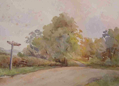
Elkington Fork. Road junction to the west of Louth, where the Lincoln Road A157 meets the Gainsborough Road A631.
Paradise Lane. Now St Mary’s Lane. This road was largely undeveloped until the 1830s.
Pade Hole. Now Northgate. Pade Hole meant Toad Hollow.
Mallard Ings. Marshy area to the east of Louth. Immediately to the north of the Riverhead, it is now housing.
Wragby Junction. Railway junction just south of Monks Dyke Road where the line from Wragby joined the main line.
Bishop’s Bridge. Bridge on the London Road over a little stream, now at the southern end of the sports ground. Presumably many centuries ago, a Bishop was instrumental in building this bridge on the main route into Louth.