Louth’s Victorian Sewer Plan
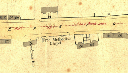
Detail of part of Eastgate
A battered document in Louth Museum, but one which is highly prized is the “Sewer Plan”. This book of detailed maps of Louth was drawn in the 1870s to show the sewers of Louth, but it also shows the frontage of every building, the location of pubs and other institutions, and gives the house numbers. It is invaluable to those researching family history in Louth.
The image above from the Sewer Plan shows a detail of Eastgate, with the Free Methodist Chapel (now a car park) and the Woodman Inn (now Louth Funeral Service).
Thanks to Ollie Smith of Louth’s Cordeaux School who recently undertook Work Experience in Louth Museum, the Museum now has digital scans of every street in the Sewer Plan.
If you would like to look at the Sewer Plan or just browse the books in Louth Museum’s Library, come to an Open Library morning on 17th October, 14th November or 12th December 2014. Booking essential - contact Louth Museum.